Wednesday, March 28, 2012

Snowy Owl visiting our neighborhood.


This Snowy Owl was seen at midday sitting on a neighbor's roof.

Tuesday, March 27, 2012

It's official. Ice OUT March 26-27th 2012.

Today was "ice out" on Chequamegon Bay. It take three things for "ice out"  warmer weather, rain and finally wind. Today March 27, 2012 we had the strong winds from the south gusting to the mid thirties.


Thursday, March 22, 2012

Moquah Barrens Sharp-tailed Grouse Viewing Opportunities - 2012


I just received and email from Brian Heeringa, Chequamegon-Nicolet National Forest, Biological Science Technician reminding the outdoor wildlife lovers that the Sharp-tailed Grouse viewing blind will soon be available for viewing the Moquah Barrens Lek

Brian Heeringa's email points out - "The blind will be set up near a lek (a lek is a gathering of males, of certain animal species, for the purposes of competitive mating display) and will be opened to the public from April 14 thru May 5, 2012."

For additional information or to signup to use the blind visit the Washburn Ranger District of the Chequamegon-Nicolet National Forest in Washburn Wisconsin or call 715-373-2667

The following video and photos were shot last year on May 5th.


It is spring and the local bird watchers are out and about. We are lucky here in northern Wisconsin to have a population of Sharp-tailed Grouse in the Moquah Barrens that are monitored by Washburn Ranger District of the Chequamegon-Nicolet National Forest. They maintain a blind that they invite wildlife lovers to use to observe spring Sharp-tailed Grouse mating behavior.


Sunday, March 18, 2012

Searching for left overs on Chequamegon Bay.

This Coyote was searching the remaining ice at West End Beach on the west of Ashland Wisconsin. At the time of the photo the Coyote was about 150 yards offshore. It eventually turned and headed northwest toward Barksdale WI.

This Eagle was luckier than the Coyote it scored the remains of a fish just 50 feet from the edge of the Hot Pond. Less than a week ago this area was covered with snow and was occupied by several ice fishermen.

Open water tells a tale.


This open run water running over the dam "tells the tale"of an active Beaver presence.  This photo was taken South of Ino WI.


This open water is connecting the Long Bridge and Short Bridge. This meeting of the waters of the two bridges "tells the tale" of  ice out in Chequamegon Bay. It is said that two weeks after the waters from Long Bridge and Short Bridge meet in the spring the ice will be out in 2 weeks. If true that would be by April 2nd this year. 

Monday, March 12, 2012

Wait a day..... the weather will change.


Sunny and warm 65 degrees . First day of 2012 (03/11/12) outside at the Black Cat.


Cooler, raining with fog around the Chequamegon Bay 03/11/12. View looking NE.


Cooler, raining with fog around the Chequamegon Bay 03/11/12. View looking NW.

Sunday, March 11, 2012

Second Ice Rescue this weekend. Submerged snowmobile, 2 rescued individuals.


Snowmobile with two self rescued passengers on the ice.


Ashland Fire Department personnel approaching snowmobile passengers.


Safely ashore with others.

Saturday, March 10, 2012

Chequamegon Bay ice rescue. Snowmobile crash with injuries.


Crash site about 3/4 mile offshore.


Crash site about 3/4 mile offshore.


Crash site. Ashland Fire Department Wind Sled "Dan B." on scene.


Fire department EMTs with patient splinted and secured.


Loading patient aboard for trip ashore.


Off loading patient from "The Dan B" wind sled.


Last move... to the ambulance.


Last move... to the ambulance.

Thursday, March 08, 2012

Work on the oredock demolition for 2012 has started.


Here is where the work day starts for the crew members who are working up on the top.  The day begins with a nice long high climb up the open scaffolding stairs. I'm guessing the wooden build at the top is a break/lunch/management building.


A view of the east side outer end of the dock. Those who are familiar with the oredock's appearance will notice the difference.

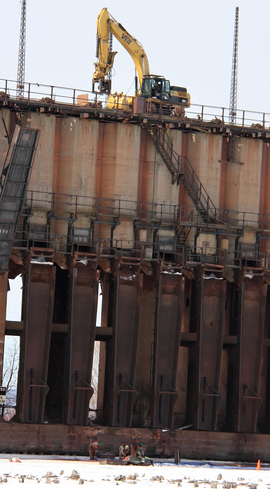
They have started demolition by lowering each individual chute one at a time. It appears that they are not detaching them completely at this time.

If my information is correct the overall height of the oredock is 90 feet. If that is the case then follow down the set of stairs from the top (seen at just below the 2nd tower from the end).

At the bottom of the steps is a gangway with a guard rail. Below the gangway (I'm guessing now) is the opening from the hoppers up above.

Below that area are the chutes that have been lowered down. The chutes are probably about 40-45 feet long.


From this view you can see, on the lower half,  2 or 3 brown support columns. To the right and left of them are the lowered chutes.


You can see the backhoe operator it this shot. Seventy five feet up on a structure "that's not safe and need to be torn down" ..... nice job.  There is not enough money to get me in that backhoe.

If you look closely at the end of the backhoe arm you can see what I believe is an hydraulic winch. My guess is that they attach the winch to the upper end of a chute then "cut it loose" and winch it down allowing it to pivot down to a hanging position. In the picture below you can see six lowered chutes (right) and one raised chute on the left. 


This shot gives you the whole picture. From top to bottom.. backhoe and  operator, stairway down to gangway, the opening from the hoppers above, the hanging chutes, the dock base and finally 4 men working on the ice cleaning up debris from the lowering of the chutes.

This is a view from the west side of the oredock. I am parked on the ice road we use to get off and on the bay.


Here is the ice road looking toward shore at Kreher Park landing.