This section of road and the fog over the valley ahead was a common sight on my morning drives to Drummond.
Photos and notes from on the road. A biologist at heart. A 'retired' network administrator and lifelong photographer. Living in Ashland Wisconsin on Lake Superior's Chequamegon Bay.
Showing posts with label landscape. Show all posts
Showing posts with label landscape. Show all posts
Friday, September 10, 2010
Tuesday, May 27, 2008
Wednesday, May 23, 2007
City flower gardens. Volunteer gardeners.

Volunteer gardeners hard at work planting this years flowers. How about the "oversight" from the past. The Captian seems pleased.
Labels:
chequamegon bay,
friends,
lake superior,
landscape,
miscellaneous,
nature scene,
plant life
Friday, May 04, 2007
Tri-County Corridor west of Ashland.

This is part of a biking trail I look forward to riding often this summer. Even though it was cool today I managed to get 10 miles in. The trip back was real cool with the wind out of the Northeast off of Lake Superior.
Saturday, March 03, 2007
A Road Less Traveled
Saturday, February 10, 2007
We went on a "trek" to the ice caves.

The point in the distances is our destination. We estimate 2.5 miles across the ice.

The scenery was wonderful. This shot is taken from the shoreline. The mounds are push ice and drifted snow with a mixture of beach sand.

The trekers on the trip out.

The view from inside one of the caves looking north, northwest.

The photo above was shot from a point just behind where my treking partner is standing in this photo.

An ice curtian. The photo doesn't do it justice.

The largest cave we venture into.

Ice was the feature of the day. Ice in all forms and sizes. These were hanging from one of the ceilings.

More of the wonderful ice formations.

On the trek back we found this snow angel.
Labels:
family,
lake superior,
landscape,
nature scene,
water,
winter
Saturday, December 23, 2006
Snow to the East.

This photo was taken along U.S. Hwy. 2 east of Ashland and just west of Hurley WI. The Hurley / Ironwood MI area had a major snow strom last night. It was nice seeing fresh snow cover. Ashland is still snow free.
Monday, December 18, 2006
Richard I. Bong Bridge.


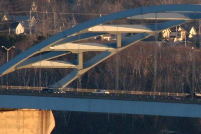
Made a road trip to Duluth MN today. Beautiful sunny day making it a great day for a ride. Very little (none) wildlife to photograph in the 140 mile round trip. I did get the chance to try out my new Canon 100-400mm lens. I thought the close up details (bottom photo) weren't bad for a hand held shot from this distant.
The photos of the Richard "Dick" I. Bong Bridge were taken from the Duluth MN Skyline Drive. The bridge connects Superior WI with Duluth MN. The bridge is a memorial to a local World War II fighter pilot.
Dick Bong was born and raised in Popular WI. He entered the U.S. Army Air Corps in the early days of World War II. He flew a P-38 Lightning and became an Ace for downing 40 enemy planes in the Pacific theater. For more information about Dick Bong visit his Heritage Center website.
Sunday, December 10, 2006
Washburn, WI shoreline.

Today was sunny and warm for December 10th. Although the Chequamegon Bay is iced over from the lighthouse to the Hwy 13 "S curve" the water north of that line is still open. This photo was taken from the park just north of Washburn.
Friday, December 08, 2006
Someone always has to be first.
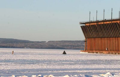

Each year someone has to be the first fisherman on the bay. This year it it's this guy. In fact it might have been two fishermen. Although I saw no one moving in and out of the teepee on the right I would guess it was occupied. Just a note the teepee probably stands about 6.5 feet tall at the apex. This should offer some perspective of the size of the Oredock.
Thursday, December 07, 2006
The changed weather.

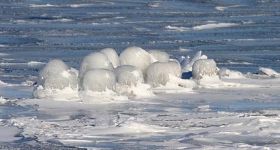
As I mentioned in yesterday's post we have had a weather change in northern Wisconsin. Frequent readers of this blog will recognize this location and similar photos taken from this location. This photo (and others) were taken from the marina behind the Chequamegon Hotel.
This is one of the spots used to survey the bay (summer and winter). Today I was looking for early Snowy Owls that might be out on the ice.
This spot is also a good location to survey the west side of the Oredock (with binoculars) looking for the Gyrfalcon which has been seen in the last few days. No luck today.
Labels:
chequamegon bay,
lake superior,
landscape,
oredock,
winter
Wednesday, December 06, 2006
Afternoon drive home.


Well it's that time of year. The afternoon drive home usually includes a sunset. Today I managed to see this hawk circling along the edge of the road. The coloration on the trailing edge of the wings is the rays from this sunset.
I believe this is a Rough-legged hawk. But I'll wait for the birders in the reading audience to confirm my ID. Ryan B. ?
In any case it's sure nice to see some wildlife out and about.
It has been really slow for several weeks. We have recently had a weather change (snow and colder temps) and this seems to have gotten things moving.
Friday, November 24, 2006
Elk hunt. Clam Lake Wisconsin.
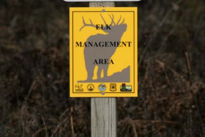

Mrs. Shutterwi and I took a road trip today to try and get some photos of a Elk. The top photo is as close as we got to seeing anything that even resembled an Elk. The area was beautiful and we did enjoy the ride along the well marked perimeter of the Elk management area. Discussion with some locals made it clear we need to be there early in the AM (before sunrise) or at dusk. We might try again in the next few days if the weather agrees.
Wednesday, November 22, 2006
View from Longbridge looking Northwest

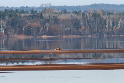
Calm November waters at the head of the Chequamegon Bay. This is a favorite viewing spot for birders in the area.
Tuesday, November 14, 2006
Cross country ski/walking trail.


It's very quiet in the woods at this time of year. Very few if any birds. Little if any color. Only the organisms of decay left to photograph and a quiet place to sit and ponder.
Saturday, November 11, 2006
Tern island and pier.

This is the remnant of one of the many piers that reached out into the Chequamegon Bay during the logging and iron ore era. The pilings from this pier at Sunset Park (Pamida Beach)are more visible this year than any other year in recent memory. The water level in the bay is at the lowest level I can remember since arriving here in 1978. The larger structure at the distant end is called "Tern Island". It is the yearly nesting ground for the Common Tern inhabiting the Chequamegon Bay area.
Subscribe to:
Posts (Atom)


